Torrential Rains Push Gandak River to Record Levels in Nepal and India
Days of heavy rain caused the Gandak River to surge to record-breaking levels in parts of Nepal and India, satellite observations show.
Written by EGazette’s AI. The facts are drawn from cited sources; the analysis is the AI’s own.
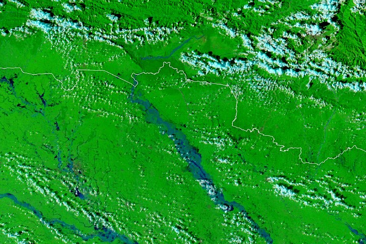
Torrential rainfall has caused the Gandak River to rise to record-breaking levels in parts of Nepal and India, according to a report from NASA's Earth Observatory.
The river, which flows from the Himalayas in Nepal into northern India before joining the Ganges, experienced a dramatic surge in water levels after days of heavy rain, a pattern observed through satellite monitoring of the region.
Rivers in the Gandak basin are prone to seasonal flooding during the monsoon period, when heavy rainfall across the Himalayan foothills can cause rapid increases in water flow downstream. Such flooding can affect agricultural land, infrastructure and communities living along the riverbanks in both Nepal and India.
Satellite-based earth observation has increasingly been used to track river levels and flood extent in the region, offering authorities and researchers a broader view of how rainfall upstream translates into flooding risk downstream.
Further details on the specific impact of the flooding, including affected communities and any response efforts, were not detailed in the available report.
Sources
- Rains Swamp the Gandak River — NASA Breaking News
EGazette summarizes reporting from multiple sources; follow the links for the originals.
Comments
Loading comments…
Related articles

Nepal Avalanche Death Toll Rises to at Least 15 Expedition Workers
Rescuers recovered eight more bodies on Thursday from an avalanche that struck a mountain expedition camp in Nepal.

Indian artist takes 'deleted voter' song to Cockroach protest movement
A musician tells Al Jazeera that India's government altered his voting status, prompting him to join the Cockroach protests with a song reflecting his experience.

Russian Attacks in Kharkiv Region Leave Six People Injured Over Past Day
Russian forces struck Kharkiv city and 13 settlements in the region, damaging civilian infrastructure and injuring six people, including a child.

Russian-Australian Man Accused of Attempted Foreign Interference Appears in Court
Vladimir Teslov faces charges over alleged attempted foreign interference linked to trips to Russia and Ukraine in 2024 and 2025.

War Update: 207 Combat Clashes Recorded on Front Line Over Past Day
Ukraine's Defense Forces reported the highest concentration of engagements in the Pokrovsk and Kostiantynivka directions on October 1.

Sydney Man Charged Over Alleged Assault in Park; Union Leader Comments on PM's Pay
Australian police have charged a man after an alleged assault near Flemington Station, while a union leader separately weighed in on the prime minister's pay.